FarrPoint have surveyed Newcastle and North Tyneside to for the first time comprehensively map out the region’s mobile phone “not spots.” Using a vehicle mounted unit FarrPoint drove more than 1,800 miles, measuring real-world 4G signal strength for the main four operators, EE, O2, Vodafone and Three.
Cllr Joyce McCarty, Newcastle City Council’s Cabinet member for inclusive economy, said: “Ensuring everyone in our area, regardless of location, age or income can access the social, cultural and economic benefits of good digital connections is essential.
“While we’ve made significant progress in increasing the availability of fixed broadband infrastructure, the levels of mobile coverage has been less clear due to the way it’s reported by mobile network operators, meaning it’s been almost impossible to identify any partial or total ‘not spots.’
“This piece of work rectifies that, accurately reflecting the on-the-ground experience that residents and businesses are likely to receive.
“It clearly shows that mobile coverage is not currently maintaining pace with developments, with areas of newer homes less likely to enjoy good signal than our more established communities.
“Having this fresh understanding will now allow us to engage with the networks in order to collaboratively try and improve coverage for everyone.”
In 2019/2020/2021 Newcastle City Council commissioned the City Listening project, which analysed social media comments to identify issues in communities that residents might not necessarily be contacting the authority about.
One of the key findings of that was concerns around mobile phone signal in some areas and so, as part of a larger £58,000 project that during the pandemic aimed to ensure children, families and businesses had the means in place to learn or work from home, this survey was undertaken.

Carried out over a two-month period the work, which was carried out by connectivity consultants FarrPoint, recorded signal strength at almost 130,000 data points. The results of this survey were used to accurately map outdoor and indoor 4G coverage (using a minimum threshold of -105 decibel milliwatts (dBm) for outdoor service and -95dBm for indoor service, the signal strength thresholds used by UK telecommunications regulator Ofcom.
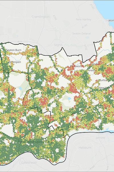
The majority of the survey area was found to have outdoor coverage from all four networks, yet in some areas such as Woolsington or where recent developments have taken place to the west and north of Newcastle, signal was more limited.
Indoor coverage followed a similar pattern, however up to 10 percent of the city was potentially found to have no adequate 4G signal, including parts of areas like Dinnington, North Gosforth, Chapel Park, Lemington, Throckley, and West Jesmond.

Map 1. Outdoor 4G mobile coverage
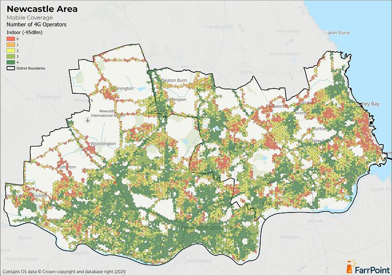
Map 2. Indoor 4G mobile coverage map
Jenny Nelson, the council’s Digital Newcastle programme manager, said: “We want Newcastle to be the best connected city that it can be and we know that has become even more important with the growth in working from home.
“This exercise has given us the real experience of residents, businesses and visitors, which in some cases is different to the data published by networks, and with this street level detail we can look to work with mobile providers to improve coverage and hopefully rid our city of “not spots.”
Dr Andrew Muir, CEO at FarrPoint, said: “We are pleased to support Newcastle City Council, using our (this will open in a new window)Mobile Coverage Mapping solution to provide an accurate picture of mobile connectivity in the region. We hope this will allow the Council to make more informed decisions and improve 4G coverage for local residents and visitors as a result.”
“With more than 1,800 miles of road surveyed, this was no small feat but, having delivered many similar projects across the UK and Canada we know how valuable this data is in resolving longstanding connectivity issues.”
FarrPoint has successfully completed similar mobile coverage maps for clients in the UK and Canada, including West Sussex County Council, Ambition North Wales and New Brunswick Government. Get in touch to find out more how this solutions could benefit your area.
Connectivity is important. It drives business and society, bringing communities and commerce together. That's why we use our insight and experience to connect people and business.