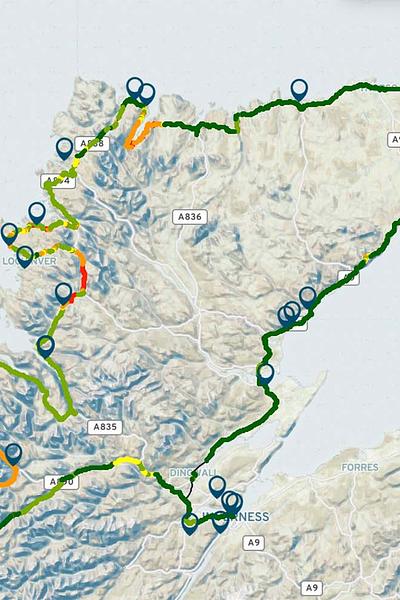
Created by FarrPoint, the new North Coast 500 map outlines the level of 4G coverage offered by the UK’s mobile network operators (EE, O2, Three and Vodafone) throughout the 516 miles of road.
View and download the NC500 Coverage Map
After surveying the length of the route which circles northern Scotland with its Coverage Mapping solution, FarrPoint identified more than 34 miles of road without 4G coverage from any provider. In addition, more than a quarter of the route is only covered by either one or two of the four mobile providers.
The digital not-spots extend across some of the most popular tourist hotspots on the road trip – including Inverewe Garden and Estate, the Applecross Peninsula, Beinn Eighe National Nature Reserve and the stunning Clachtoll Beach.
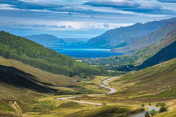
Photo: Beinn Eighe National Nature Reserve is an area affected by poor 4G coverage
Despite its undeniable beauty and fantastic scenery, drivers can quickly run into issues navigating the winding country roads, especially if they deviate off the main road to visit nearby businesses or beauty spots. FarrPoint is encouraging drivers to consider downloading digital maps before setting off on the epic road trip so they can be accessed in not-spot areas, as well as checking the level of coverage that specific mobile operators offer.

Photo: Inverewe Garden and Estate is another tourism spot on NC500 that's affect by poor 4G coverage.
According to FarrPoint’s analysis, EE was found to offer the best coverage (89% of the route includes access to its network), closely followed by O2 (77%) and Vodafone (76%). Three came last, only providing coverage for 51% of the route – leaving more than 252 miles without 4G coverage.
Andrew Muir, CEO, FarrPoint said: “With stunning scenery and views, the North Coast 500 provides the setting for one of the world’s best road journeys right here in Scotland. But without adequate preparation, the trip could turn into difficulty in parts given the remote nature of the surrounding area and the limited connectivity across the route.
“With more than 34 miles of the route having no 4G coverage from any operator, and hundreds of miles of road only being covered by certain operators, undoubtedly people will experience connectivity issues during their journey. This may appeal to some travellers who are looking to have a break from their digital devices, but it could equally cause issues if drivers get lost or run into trouble. To help provide better peace of mind, we recommend that drivers check their mobile connectivity and download any maps of areas before they set off to ensure they don’t get lost in this remote, albeit undeniably beautiful part of northern Scotland.”
FarrPoint has made an interactive version of the map available for use, and visitors are encouraged to look at what their operator’s coverage levels are in advance so they can make informed decisions before they travel.
FarrPoint has mapped 4G coverage in (this will open in a new window)other locations across Scotland, the UK and Canada, working with local authorities and governments to assist them in building an accurate picture of connectivity so that infrastructure investment decisions can be made more effectively. To date, the business has advised on more than £3.5bn worth of connectivity infrastructure projects, including £1.5bn in the past year.
Notes to editors:
- This map is based on a recorded outdoor 4G service at any threshold from a Mobile Network Operator.
- This map is based on a recorded outdoor 4G service at any threshold from a Mobile Network Operator.ng device which builds an accurate picture of connectivity by identifying locations that receive limited to no mobile coverage across all major MNOs (mobile network operators). Unlike other solutions, it does not require the expertise of engineers or technicians to man a vehicle with specialist equipment and can be fitted into any vehicle as it drives the route of interest.
FarrPoint is an independent technology consultancy which specialises in digital connectivity. It provides independent advice on the commercial and technical considerations of the design of national and regional connectivity strategies, technical planning and modelling, procurement support and implementation assurance.
The team comprise a mix of consulting technologists, economists and data scientists who work together to provide experience, expertise and complementary resource to clients in the public and private sectors.
Connectivity is important. It drives business and society, bringing communities and commerce together. That's why we use our insight and experience to connect people and business.