We are proud to have developed an innovative and cost-effective cellular coverage mapping and assurance solution. It provides independent assurance of cellular service coverage for each available service provider in a given area. The result is an interactive real-world visualization based on measured signal strength data, highlighting areas with no coverage or low coverage across all service providers.
About FarrPoint's Cellular Mapping Solution
Watch FarrPoint's video which explains how the mapper works and details the benefits it can provide.
How does our cellular coverage survey solution work?
Our cellular coverage mapper is an autonomous network monitoring tool that provides real-world performance statistics of all available cellular networks in the surveyed area. The unit is typically placed in the trunk of a vehicle and powered by the 12V auxilliary power plug. Up to five small antennae are temporarily mounted on the trunk lid. During the survey period, the unit simultaneously measures cellular signal strength of each carrier’s signal in the surveyed area. The data is sent to Farrpoint’s cloud servers in real time for processing. Units can also be mounted in utility vehicles for long-term measurement. The result is an independent physical survey of Cellular coverage producing a true picture of service availability.
We've helped various clients to accurately define cellular coverage in their area
Along with many projects in the UK, our Mapper has been deployed in Canada in New Brunswick and Nova Scotia, providing public agencies with accurate cellular coverage information across all service providers. The mapper is typically installed on utility vehicles that travel extensively within the jurisdiction in question. The mapper can be easily installed in any vehicle, including ATVs. There is a backpack version that can even be carried on foot on wilderness trails.
Why knowing actual signal coverage data is important?
Identification of 4G and 5G cellular coverage gaps for public safety.
Ensuring that emergency alert messages reach all residents.
Understanding coverage differences between service providers.
Understanding the need for new towers following requests from service providers.
Ensuring coverage for IoT services with an emphasis on agricultural and forestry requirements.
Contractual acceptance and verification for publicly funded projects.
Benefits of getting independent cellular coverage data in your area
Significantly lower costs than standard drive test surveying, which requires specialised resources and equipment
Visualization of 4G and 5G coverage gaps, which can be used to provide feedback to service providers
Provides independent coverage assurance and verification allowing for planning and evaluation of emergency communication systems, meeting commercial requirements, and enabling agricultural and forestry related IoT applications.
Our mapper is autonomous, easily installed in any vehicle, and requires no technical knowledge to operate.
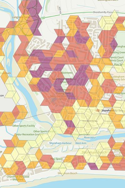
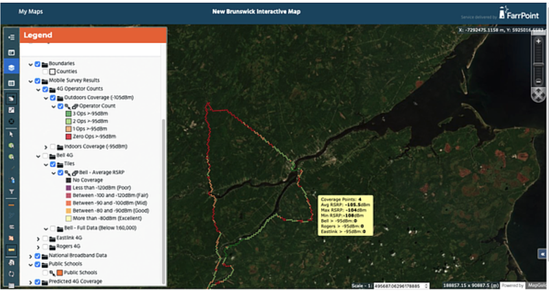
Mapping examples
Image 1: New Brunswick cellular coverage interactive map
Image 2: Newcastle covered for all UK operators
Key features
Independent & real-time monitoring of 4G/5G network performance in outdoor areas
Our Cellular Coverage Mapper is autonomous, installed easily to any vehicle and requires no technical knowledge
Logs multiple engineering parameters including signal strength, channel parameters and location data
Results and analysis are stored in a secure central database and presented on a secure mapping portal in real-time
Survey results are presented in a simple visual format. No technical knowledge required to interpret results
Scalable design - multiple units can be deployed across areas, simultaneously collecting data to continuously build up a library of cellular network measurements across a geography
Connectivity is important. It drives business and society, bringing communities and commerce together. That's why we use our insight and experience to connect people and business.